Contents
Overview
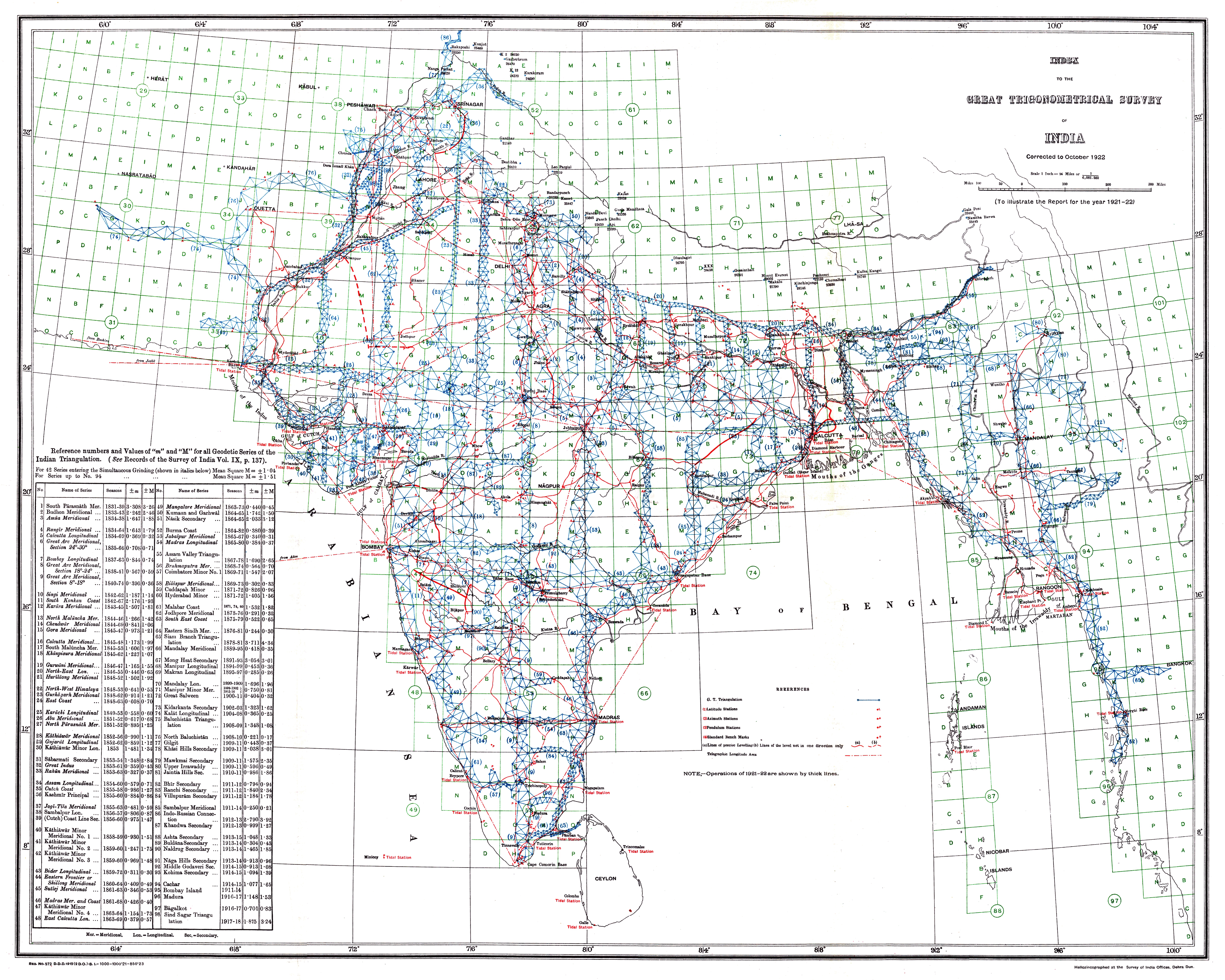
The Great Trigonometrical Survey of India was initiated in 1802 by William Lambton, a British infantry officer, under the auspices of the East India Company. The project was later led by George Everest, who played a crucial role in shaping the survey's methodology and objectives. The survey's findings were instrumental in demarcating British territories in the subcontinent and measuring the height of Himalayan giants, including Mount Everest, K2, and Kangchenjunga. The survey's native surveyors, such as Nain Singh, made significant contributions to the project's success.
📏 How It Worked
The survey's methodology involved the use of triangulation, a technique that allowed for the calculation of distances and heights with great precision. This approach enabled the survey team to create detailed maps of the region, which were essential for administrative and military purposes. The survey's measurements of the geodesic anomaly led to the development of theories of isostasy, a concept that explains the balance between the Earth's crust and mantle. The survey's work was also influenced by the ideas of Alexandre Ross, a French geographer who had conducted similar surveys in other parts of the world.
🌄 Cultural Impact
The Great Trigonometrical Survey of India had a profound impact on the cultural and scientific landscape of the region. The survey's findings helped to shape the British colonial administration's understanding of the subcontinent's geography and resources. The survey also facilitated the development of infrastructure, such as roads and railways, which had a lasting impact on the region's economy and society. The survey's legacy can be seen in the work of later cartographers and scientists, such as James Walker, who built upon the survey's findings to create even more detailed and accurate maps of the region.
🔍 Legacy & Future
The Great Trigonometrical Survey of India's legacy extends beyond its immediate impact on the region. The survey's methodologies and findings have influenced the development of cartography and geodesy worldwide. The survey's use of triangulation and its measurements of the geodesic anomaly have become standard practices in the field. The survey's legacy can also be seen in the work of modern-day scientists, such as David Keating, who continue to build upon the survey's findings to advance our understanding of the Earth's geography and geology.
Key Facts
- Year
- 1802-1871
- Origin
- India
- Category
- history
- Type
- concept
Frequently Asked Questions
What was the primary objective of the Great Trigonometrical Survey of India?
The primary objective of the survey was to create a detailed and accurate map of the Indian subcontinent, which would facilitate administrative and military purposes. The survey was led by notable figures such as George Everest and William Lambton, and its findings had a profound impact on the region's geography and resources.
How did the survey contribute to the development of geodesy?
The survey's measurements of the geodesic anomaly led to the development of theories of isostasy, a concept that explains the balance between the Earth's crust and mantle. The survey's use of triangulation and its findings on the geodesic anomaly have become standard practices in the field of geodesy, influencing the work of later scientists such as David Keating.
What was the significance of the survey's findings on the height of Himalayan giants?
The survey's measurements of the height of Himalayan giants, including Mount Everest, K2, and Kangchenjunga, were instrumental in shaping our understanding of the region's geography and resources. The survey's findings also facilitated the development of infrastructure, such as roads and railways, which had a lasting impact on the region's economy and society.
How did the survey impact British colonial administration?
The survey's findings helped to shape the British colonial administration's understanding of the subcontinent's geography and resources. The survey's maps and measurements facilitated the development of infrastructure, such as roads and railways, which had a lasting impact on the region's economy and society. The survey's legacy can be seen in the work of later cartographers and scientists, such as James Walker, who built upon the survey's findings to create even more detailed and accurate maps of the region.
What is the legacy of the Great Trigonometrical Survey of India?
The survey's legacy extends beyond its immediate impact on the region. The survey's methodologies and findings have influenced the development of cartography and geodesy worldwide. The survey's use of triangulation and its measurements of the geodesic anomaly have become standard practices in the field, and its legacy can be seen in the work of modern-day scientists, such as David Keating.