Summary
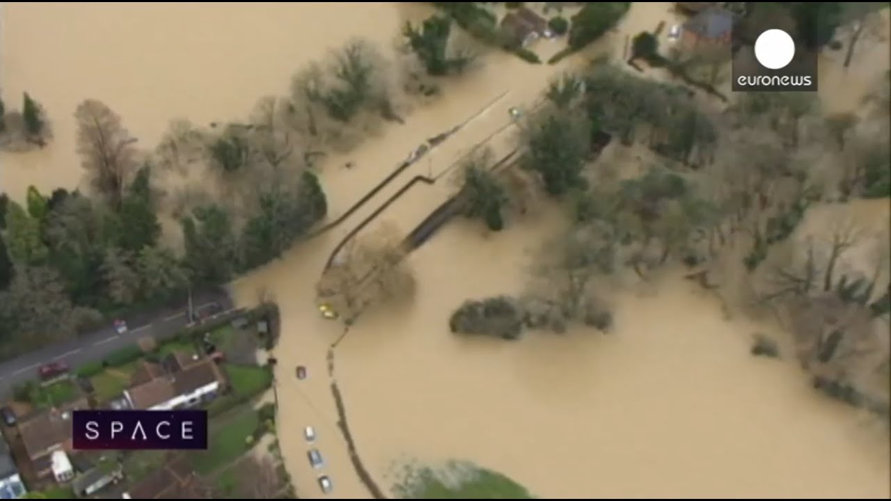
The **European Space Agency (ESA)** has provided satellite imagery from its **ERS-1**, **ERS-2**, and **Envisat** satellites to support flood relief efforts in Europe, particularly in the wake of the devastating **Elbe River** flooding. The imagery has been used to predict flood peaks, aid in relief and damage assessment efforts, and generate digital elevation models to plan for future flood scenarios. The **International Charter on Space and Major Disasters** was activated by **Switzerland**, **Austria**, and **Germany** to request satellite images and support national, regional, and local authorities in coping with the flooding. The Charter has provided 30 images from the ERS and Envisat satellites, with more being prepared. The **Envisat** satellite's advanced synthetic aperture radar (ASAR) has proven useful in providing flood information over a wide swath of territory. The ERS data is being used to generate a digital elevation model to assist authorities in planning for future flood scenarios, such as simulating different scenarios and identifying areas that would be flooded depending on the water level. For more information on the ESA and its missions, visit the [[european-space-agency|European Space Agency]] page. The use of satellite imagery in flood relief efforts is also related to the topic of [[disaster-response|disaster response]] and [[remote-sensing|remote sensing]].
Key Takeaways
- The European Space Agency (ESA) provided satellite imagery from its ERS-1, ERS-2, and Envisat satellites to support flood relief efforts in Europe.
- The International Charter on Space and Major Disasters was activated by Switzerland, Austria, and Germany to request satellite images and support national, regional, and local authorities in coping with the flooding.
- The Envisat satellite's advanced synthetic aperture radar (ASAR) has proven useful in providing flood information over a wide swath of territory.
- The use of satellite imagery in flood relief efforts can help save lives, reduce damage to infrastructure, and support more effective response and recovery efforts.
- International cooperation is critical in responding to natural disasters, and the International Charter on Space and Major Disasters has played a crucial role in facilitating the provision of satellite imagery.
Balanced Perspective
The provision of satellite imagery by the ESA has been a valuable resource for crisis managers and civil agencies responding to the flooding in Europe. The images have provided critical information on flood extent, damage to infrastructure, and areas of high flood risk. However, the effectiveness of the satellite imagery in supporting relief efforts depends on various factors, including the quality of the images, the timing of their provision, and the ability of authorities to interpret and act on the information. As noted by [[dr-urs-frei|Dr. Urs Frei]], the coordinator of the Swiss effort to support the delivery of pumps and power generators to flooded areas, the ERS data is being used to generate a digital elevation model to assist authorities in planning for future flood scenarios. For more information on the use of satellite imagery in flood risk management, visit the [[flood-risk-management|flood risk management]] page.
Optimistic View
The use of satellite imagery in flood relief efforts is a **game-changer** for crisis managers and civil agencies. The high-resolution images provided by the ERS and Envisat satellites have enabled authorities to respond more effectively to the flooding, saving lives and reducing damage to infrastructure. The **International Charter on Space and Major Disasters** has played a crucial role in facilitating the provision of satellite imagery, demonstrating the importance of international cooperation in responding to natural disasters. As noted by [[dr-stefan-voigt|Dr. Stefan Voigt]], the charter coordinator for the German and Austrian requests, the satellite imagery has been instrumental in supporting the relief efforts. For more information on the benefits of satellite imagery in disaster response, visit the [[satellite-imagery-in-disaster-response|satellite imagery in disaster response]] page.
Critical View
While the provision of satellite imagery by the ESA has been helpful in supporting flood relief efforts, there are concerns about the limitations of the technology and the potential for **information overload**. The sheer volume of data provided by the ERS and Envisat satellites can be overwhelming for authorities, making it difficult to extract meaningful insights and take effective action. Additionally, the reliance on satellite imagery may divert attention and resources away from other critical aspects of flood relief, such as search and rescue operations and provision of emergency aid. As noted by [[european-space-agency|European Space Agency]], the use of satellite imagery in flood relief efforts is just one part of a broader response strategy. For more information on the challenges of using satellite imagery in disaster response, visit the [[challenges-of-using-satellite-imagery|challenges of using satellite imagery]] page.
Source
Originally reported by esa.int