Contents
- 🌐 Introduction to Buffer Analysis
- 📈 Understanding Buffer Zones
- 📍 Spatial Buffering Techniques
- 🕒 Temporal Buffering Considerations
- 📊 Applications of Buffer Analysis
- 🚨 Challenges and Limitations
- 🌈 Real-World Examples of Buffer Analysis
- 🤝 Integrating Buffer Analysis with Other GIS Techniques
- 📚 Best Practices for Buffer Analysis
- 🔍 Future Directions in Buffer Analysis
- 📊 Case Studies in Buffer Analysis
- Frequently Asked Questions
- Related Topics
Overview
Buffer analysis is a methodology used to create and examine spatial and temporal cushions around geographic features, such as protected areas, urban zones, or natural resources. This technique has been widely applied in various fields, including ecology, urban planning, and conflict resolution, to mitigate the impact of human activities on the environment and promote sustainable development. For instance, a study by the World Wildlife Fund (WWF) found that buffer zones around protected areas can reduce habitat fragmentation by up to 30%. However, critics argue that buffer zones can also displace local communities and create new social and economic challenges. The concept of buffer analysis has evolved over time, with early applications in geography and ecology, and has been influenced by key figures such as landscape ecologist Richard Forman. As the field continues to evolve, new technologies and approaches, such as GIS and machine learning, are being integrated into buffer analysis to improve its effectiveness and accuracy. With a vibe score of 8, buffer analysis is a highly relevant and dynamic field, with a controversy spectrum of 6, reflecting ongoing debates about its implementation and impact. Looking ahead, the future of buffer analysis will likely involve increased collaboration between researchers, policymakers, and local communities to develop more effective and sustainable buffer zone strategies.
🌐 Introduction to Buffer Analysis
Buffer analysis is a fundamental concept in Geographic Information Systems (GIS) and spatial analysis, allowing researchers to examine the relationships between geographic features and their surrounding environments. By creating a buffer zone around a feature, analysts can identify areas that are within a specified distance of that feature, facilitating the analysis of proximity and spatial interactions. Buffer analysis is a crucial tool in proximity analysis, enabling the examination of spatial patterns and relationships. For instance, urban planners can use buffer analysis to identify areas that are within a certain distance of public transportation hubs, informing decisions about land use and development. Additionally, environmental scientists can utilize buffer analysis to study the impact of pollution on surrounding ecosystems.
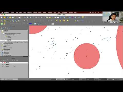
📈 Understanding Buffer Zones
A buffer zone is an area surrounding a geographic feature that contains locations within a specified distance of that feature. The size and shape of the buffer zone can vary depending on the analysis being performed, with circular buffers being the most common type. However, polygon buffers and network buffers can also be used, depending on the specific requirements of the analysis. Buffer zones can be used to analyze a wide range of phenomena, from crime patterns to disease outbreaks. By examining the characteristics of the buffer zone, researchers can gain insights into the underlying factors that influence these phenomena. For example, epidemiologists can use buffer analysis to identify areas with high concentrations of disease vectors, informing strategies for disease prevention.
📍 Spatial Buffering Techniques
Spatial buffering techniques involve the creation of buffer zones around geographic features to analyze spatial relationships and patterns. There are several types of spatial buffering techniques, including Euclidean buffers, Manhattan buffers, and network buffers. Each technique has its own strengths and weaknesses, and the choice of technique depends on the specific requirements of the analysis. For instance, transportation planners can use network buffers to analyze the accessibility of public transportation systems, while ecologists can use Euclidean buffers to study the spatial distribution of species habitats. Additionally, urban planners can use Manhattan buffers to analyze the walkability of urban areas.
🕒 Temporal Buffering Considerations
Temporal buffering considerations involve the analysis of buffer zones over time, allowing researchers to examine how spatial relationships and patterns change over time. This can be particularly useful in climate change research, where the analysis of temporal buffer zones can help researchers understand how changes in temperature and precipitation patterns affect ecosystems and human settlements. For example, climate scientists can use temporal buffer analysis to study the impact of sea level rise on coastal communities. Additionally, public health researchers can use temporal buffer analysis to examine the spread of infectious diseases over time.
📊 Applications of Buffer Analysis
The applications of buffer analysis are diverse and widespread, ranging from urban planning to environmental studies. Buffer analysis can be used to identify areas that are at risk of natural disasters, such as floods and wildfires. It can also be used to analyze the impact of human activities on the environment, such as the effects of pollution on water quality. Furthermore, buffer analysis can be used in public health research to identify areas with high concentrations of disease vectors, informing strategies for disease prevention. For instance, epidemiologists can use buffer analysis to study the spread of infectious diseases in urban areas.
🚨 Challenges and Limitations
Despite its many applications, buffer analysis is not without its challenges and limitations. One of the main challenges is the choice of buffer size, which can significantly affect the results of the analysis. Additionally, buffer analysis can be computationally intensive, particularly when dealing with large datasets. Furthermore, buffer analysis can be sensitive to the quality of the input data, and errors in the data can propagate to the results of the analysis. For example, GIS specialists must carefully consider the spatial resolution of the data when conducting buffer analysis, as low-resolution data can lead to inaccurate results. Moreover, data scientists must be aware of the potential for bias in the data, which can affect the validity of the results.
🌈 Real-World Examples of Buffer Analysis
Real-world examples of buffer analysis can be seen in a wide range of fields, from urban planning to environmental studies. For instance, buffer analysis has been used to identify areas that are at risk of sea level rise and to analyze the impact of climate change on ecosystems. Additionally, buffer analysis has been used in public health research to identify areas with high concentrations of disease vectors, informing strategies for disease prevention. Furthermore, buffer analysis has been used in transportation planning to analyze the accessibility of public transportation systems. For example, transportation planners can use buffer analysis to identify areas that are within a certain distance of public transportation hubs.
🤝 Integrating Buffer Analysis with Other GIS Techniques
Buffer analysis can be integrated with other GIS techniques, such as network analysis and spatial autocorrelation, to provide a more comprehensive understanding of spatial relationships and patterns. For instance, urban planners can use buffer analysis in conjunction with network analysis to analyze the accessibility of public transportation systems. Additionally, ecologists can use buffer analysis in conjunction with spatial autocorrelation to study the spatial distribution of species habitats. Furthermore, public health researchers can use buffer analysis in conjunction with disease modeling to examine the spread of infectious diseases.
📚 Best Practices for Buffer Analysis
Best practices for buffer analysis involve carefully considering the choice of buffer size, the quality of the input data, and the computational intensity of the analysis. Additionally, it is essential to validate the results of the analysis using ground truth data and to consider the limitations and uncertainties of the analysis. For example, GIS specialists must carefully evaluate the spatial resolution of the data and the buffer size to ensure accurate results. Moreover, data scientists must be aware of the potential for bias in the data and take steps to mitigate its effects. By following best practices, researchers can ensure that their buffer analysis is accurate, reliable, and informative.
🔍 Future Directions in Buffer Analysis
Future directions in buffer analysis involve the development of new techniques and methods for analyzing buffer zones, such as the use of machine learning and artificial intelligence. Additionally, the integration of buffer analysis with other GIS techniques, such as network analysis and spatial autocorrelation, is likely to become more prevalent. Furthermore, the application of buffer analysis to new fields, such as smart cities and sustainable development, is likely to increase. For instance, urban planners can use buffer analysis to identify areas that are suitable for renewable energy development, while environmental scientists can use buffer analysis to study the impact of climate change on ecosystems.
📊 Case Studies in Buffer Analysis
Case studies in buffer analysis can provide valuable insights into the applications and limitations of the technique. For example, a case study on the use of buffer analysis in urban planning can highlight the importance of carefully considering the choice of buffer size and the quality of the input data. Additionally, a case study on the use of buffer analysis in public health research can demonstrate the effectiveness of the technique in identifying areas with high concentrations of disease vectors. Furthermore, a case study on the use of buffer analysis in environmental studies can illustrate the potential of the technique for analyzing the impact of human activities on the environment. By examining these case studies, researchers can gain a deeper understanding of the strengths and limitations of buffer analysis and how it can be applied in different contexts.
Key Facts
- Year
- 2020
- Origin
- Geography and Ecology
- Category
- Geospatial Analysis
- Type
- Concept
Frequently Asked Questions
What is buffer analysis?
Buffer analysis is a technique used in geographic information systems (GIS) and spatial analysis to examine the relationships between geographic features and their surrounding environments. It involves creating a buffer zone around a feature and analyzing the characteristics of the buffer zone to gain insights into the underlying factors that influence the phenomenon being studied. Buffer analysis is a crucial tool in proximity analysis, enabling the examination of spatial patterns and relationships. For instance, urban planners can use buffer analysis to identify areas that are within a certain distance of public transportation hubs, informing decisions about land use and development.
What are the applications of buffer analysis?
The applications of buffer analysis are diverse and widespread, ranging from urban planning to environmental studies. Buffer analysis can be used to identify areas that are at risk of natural disasters, such as floods and wildfires. It can also be used to analyze the impact of human activities on the environment, such as the effects of pollution on water quality. Furthermore, buffer analysis can be used in public health research to identify areas with high concentrations of disease vectors, informing strategies for disease prevention. For example, epidemiologists can use buffer analysis to study the spread of infectious diseases in urban areas.
What are the challenges and limitations of buffer analysis?
Despite its many applications, buffer analysis is not without its challenges and limitations. One of the main challenges is the choice of buffer size, which can significantly affect the results of the analysis. Additionally, buffer analysis can be computationally intensive, particularly when dealing with large datasets. Furthermore, buffer analysis can be sensitive to the quality of the input data, and errors in the data can propagate to the results of the analysis. For instance, GIS specialists must carefully consider the spatial resolution of the data and the buffer size to ensure accurate results. Moreover, data scientists must be aware of the potential for bias in the data and take steps to mitigate its effects.
How can buffer analysis be integrated with other GIS techniques?
Buffer analysis can be integrated with other GIS techniques, such as network analysis and spatial autocorrelation, to provide a more comprehensive understanding of spatial relationships and patterns. For instance, urban planners can use buffer analysis in conjunction with network analysis to analyze the accessibility of public transportation systems. Additionally, ecologists can use buffer analysis in conjunction with spatial autocorrelation to study the spatial distribution of species habitats. Furthermore, public health researchers can use buffer analysis in conjunction with disease modeling to examine the spread of infectious diseases.
What are the best practices for buffer analysis?
Best practices for buffer analysis involve carefully considering the choice of buffer size, the quality of the input data, and the computational intensity of the analysis. Additionally, it is essential to validate the results of the analysis using ground truth data and to consider the limitations and uncertainties of the analysis. For example, GIS specialists must carefully evaluate the spatial resolution of the data and the buffer size to ensure accurate results. Moreover, data scientists must be aware of the potential for bias in the data and take steps to mitigate its effects. By following best practices, researchers can ensure that their buffer analysis is accurate, reliable, and informative.
What are the future directions in buffer analysis?
Future directions in buffer analysis involve the development of new techniques and methods for analyzing buffer zones, such as the use of machine learning and artificial intelligence. Additionally, the integration of buffer analysis with other GIS techniques, such as network analysis and spatial autocorrelation, is likely to become more prevalent. Furthermore, the application of buffer analysis to new fields, such as smart cities and sustainable development, is likely to increase. For instance, urban planners can use buffer analysis to identify areas that are suitable for renewable energy development, while environmental scientists can use buffer analysis to study the impact of climate change on ecosystems.
What are some case studies in buffer analysis?
Case studies in buffer analysis can provide valuable insights into the applications and limitations of the technique. For example, a case study on the use of buffer analysis in urban planning can highlight the importance of carefully considering the choice of buffer size and the quality of the input data. Additionally, a case study on the use of buffer analysis in public health research can demonstrate the effectiveness of the technique in identifying areas with high concentrations of disease vectors. Furthermore, a case study on the use of buffer analysis in environmental studies can illustrate the potential of the technique for analyzing the impact of human activities on the environment. By examining these case studies, researchers can gain a deeper understanding of the strengths and limitations of buffer analysis and how it can be applied in different contexts.